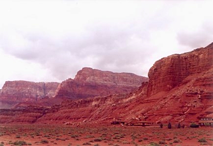
Embarking on a journey through the Vermilion Cliffs requires a blend of careful planning and adventurous spirit. This three-day itinerary is designed to take you from the convenient gateway of Page, Arizona, deep into the heart of the monument's most spectacular landscapes. Since the terrain is rugged and services are non-existent once you leave the highway, this plan emphasizes self-sufficiency, highlighting the need for a high-clearance vehicle and plenty of supplies to ensure a safe and memorable desert exploration.
Day 1: Arrival and the Narrows of Buckskin
Start your journey by flying into Page Municipal Airport (PGA). After picking up your high-clearance rental vehicle, make the 45-mile drive west toward the House Rock Valley Road entrance. Your first stop is Wire Pass Trailhead, the most accessible gateway to the famous Buckskin Gulch. Spend your morning hiking through the Wire Pass slot, which features a short, dramatic section of narrow walls and a small wooden ladder navigation. Once you reach the confluence with Buckskin Gulch, turn right and explore as far as you feel comfortable.
The towering walls and undulating sandstone provide an immediate immersion into the monument's scale. After your hike, head back to your vehicle and drive south along House Rock Valley Road to find a spot for a scenic picnic. If you have time, stop by the California Condor release site nearby to scan the cliffs for these prehistoric-looking birds. As evening approaches, settle into your chosen accommodationâwhether a campsite under the stars or a lodge in nearby Marble Canyonâand prepare for a full day of trekking ahead.
Day 2: The Quest for Sandstone Wonders
Day two is dedicated to the crown jewels of the monument. If you were lucky enough to secure a permit for Coyote Buttes North, this is your day to visit The Wave. Start at dawn to beat the heat and enjoy the changing light on the rock formations. The six-mile round-trip hike is moderately strenuous and requires following a map or GPS, as there are no trail markers. You will spend hours mesmerized by the 'Second Wave' and the 'Big Elbow,' capturing photos that look like paintings.
For those without a Wave permit, today is the day to explore White Pocket. This requires a capable 4WD vehicle to navigate the deep sand of the backcountry tracks. White Pocket offers an incredible alternative with its swirling 'brain rock' and white-capped domes. Because there are no permits required for White Pocket, it is a stress-free way to experience the best of the monumentâs geology. Spend the afternoon wandering the hexagonal patterns and colorful pools, staying until sunset when the rock glows in brilliant oranges and reds before driving back to your base camp.
Day 3: River Views and Desert Departures
On your final day, take a more relaxed approach by exploring the fringes of the monument where the cliffs meet the Colorado River. Drive to Leeâs Ferry, the only place for hundreds of miles where you can drive right to the water's edge. Take a walk along the River Trail to see the historic buildings of the lonely outpost and watch the rafters begin their multi-week journey through the Grand Canyon. The contrast of the emerald green water against the towering red cliffs is a sight you won't soon forget.
Before heading back to the airport, stop at the Navajo Bridge Interpretive Center. Walking across the old bridge offers a dizzying view of the river 467 feet below. If you have an hour to spare, hike the Spencer Trail for a bird's-eye view of the river's bend. After soaking in the last of the desert vistas, make the one-hour drive back to Page. Refuel your vehicle and grab a final meal in town before checking into your flight, carrying with you the silence and scale of the Vermilion Cliffs.
Essential Packing and Logistics
Success in the Vermilion Cliffs depends on your gear. The desert is unforgiving, so your packing list must include at least one gallon of water per person per day, high-SPF sunscreen, and a wide-brimmed hat. Sturdy, broken-in hiking boots are essential for navigating the uneven slickrock and deep sand. Because cell service is non-existent in the monument, you should download offline maps (like Gaia GPS or Google Maps) and carry a physical map as a backup. A satellite communication device is highly recommended for emergency situations.
Regarding transportation, do not underestimate the roads. While House Rock Valley Road is often graded, it can be impassable for sedans after rain. For off-road sections like the path to White Pocket, a standard SUV may not be enough; true four-wheel drive with high clearance and aired-down tires is often necessary. If you aren't experienced in deep sand driving, consider booking a local shuttle service. This ensures you spend your time looking at the scenery rather than worrying about getting stuck in a remote wash miles from help.
Permit Strategy and Backup Plans
Since many of the highlights in this itinerary require permits, your planning should start months in advance. Apply for the online lottery four months ahead of your trip. If you miss out, try the daily lottery via the BLM website while you are in the local geofenced area (Kanab or Page). Always have a 'Plan B' ready. The Vermilion Cliffs area is surrounded by other stunning public lands, including Grand Staircase-Escalante and the Glen Canyon National Recreation Area.
If the weather forecast calls for rain, pivot immediately. Slot canyons like Buckskin Gulch are death traps during storms, and the roads will likely trap your vehicle. Use rainy days to explore the museums in Kanab or take the paved drive to the North Rim of the Grand Canyon if it is open. By staying flexible and respecting the desertâs power, you ensure that your trip to the Vermilion Cliffs is a highlight of your travel history rather than a series of logistical frustrations. Always check the official NPS or BLM websites for the most current trail and road status before you leave.

More ways to book Vermilion Cliffs
 Illustrative · Diego Angel
Sprinter Adventure Van
Small enough to park at the trailhead, comfy enough to sleep in.
$189/day (estimate)
Direct link · RVshare